Under a mega project managed by PHPA II (an autonomous body set up by governments of Bhutan and India), a hydroelectric dam construction site in Bhutan suffered the collapse of a roof inside the main access tunnel which resulted in loss of life and a significant delay in progress. Owing to the fact that surveying cavities in underground excavation projects can not only be difficult but extremely dangerous, the project participants were unable to continue the tunnel work until they could ascertain the size and condition of the cavity that remained above the caved-in debris, blocking the chamber.
To do the challenging surveying, PHPA II roped in Roter Precision Instruments Pvt. Ltd. which is the oldest manufacturing company in India for surveying, drawing and mathematical instruments. Roter survey team evaluated the options for surveying the interior of the deep, inaccessible cavern by 3D Laser Scanner.
A nearly vertical 150m-long borehole with a diameter of 205mm (the widest diameter possible with the boring equipment available to PHPA) had been drilled from the exterior down into the cavity, providing some insight for PHPA. Roter survey team used a total station to measure ground control points both outside and inside the tunnel to tie the captured 3D scan data into the project coordinate system. The team also surveyed the surface location of the borehole. Engineers used the planning data to create a 3D model of the tunnel for incorporation into an existing terrain model of the entire site.
The result was that the point cloud revealed a large cavity with undulating walls and an undefined shape. The 3D Laser Scanner took thousands of measurements inside the cavity and the software determined its overall volume. The coordinate data precisely located the void space in the existing 3D model of the project site. This information gave the engineers a better understanding of the conditions in the area where the collapse had occurred and enabled them to begin formulating a plan to resume excavation in the main tunnel.
Expertise In Surveying And Mapping
It is through feats like the afore mentioned that Roter Precision Instruments has earned a reputation in providing surveying and mapping technology solutions. Established in 1936, the company has been a witness to every technological evolution from mechanical to opto-mechanical, from opto-electrical to GNSS, and from LiDAR to IoTs.
“We ventured into software development 30 years back to integrate any kind of surveying instrument into CAD based software. We started geospatial production for foreign companies 20 years back. We also started investment in drones almost eight years back. We understand the nuances of manufacturing as well as applications of such instruments in the field. There is no other company in the world which can do all that under one umbrella,” says Sajid Mukhtar, Chairman, Roter Precision Instruments.
At a time when the surveying and mapping services market landscape is reshaping rapidly with adoption of new technologies and supportive policy initiatives by the government, Roter is well poised in the market with its extensive experience and expertise. The company has abundant experience in this field and is adequately equipped to build up expertise in terms of the hardware used and its latest design and features.
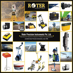
The company started with Levels, theodolites, Total Station, GNSS & LiDAR. It is now customizing its instruments and bundling them with software for varied applications. For example, LiDAR - the laser module can come in from Canada or Germany but the platform with solutions for on-the-ground, underground or in-the-air is being offered by Roter. Such an amalgamation of sensors and solutions can rarely be found at one place.
Legacy And Knowledge
With a legacy and knowledge of more than 85 years, Roter is today providing end-to-end solutions for various clients. It was the first company to bring in Engineering grade LiDAR in India for Mobile Mapping, is still one of the leaders in providing LiDAR on a drone. In addition to its groundbreaking achievements, the company’s experience of more than eight decades has enabled it to leverage the collected data for various interpretations. “We do not provide just a topography map in standard formats to meet the specifications on paper, but also meet the project requirements with photogrammetry, DEM, DSM, etc.
while digitizing a whole load of catalogue used for floodplain mapping, forest, agriculture health, animal tracking, etc. Our deliverables are packaged with our software to be extensively used by our clients with ease. This makes our data suitable for mapping, planning and engineering requirements of any project,” adds Sajid.

A remarkable journey Roter Precision Instruments was founded in 1936 as Ansari Precision Instruments by a freedom fighter Late Mr. B.A. Ansari who espoused a vision of making India self-reliant. The second generation joined hands with a German company to build India’s largest Levels and Theodolite manufacturing unit.
Taking the company further on the path of growth, the third generation took it forward not only acquiring western technology but complete companies in the overseas market. The acquisition of Roter Engineering LLC in Toledo Ohio (USA) and Roter International GmbH (Germany) not only expanded the company’s footprint outside India but also gave it the much needed technological platform that India as a developing country was missing.
Speaking of the company philosophy, Sajid says, “We come from the land of Lord Shiva (Uttarakhand) and the company firmly believes in Shiva’s threefold power of will (icchāśakti), knowledge (jñānaśakti), and action (kriyāśakti). That’s where our company differentiates itself from others as we have the WILL to acquire KNOWLEDGE and then put that knowledge into ACTION!”
Acknowledged By The Government
Recently Ministry of Civil Aviation along with Airport Authority of India and FICCI conferred “The best Drone Company” WINGS INDIA award 2022 to ROTER. The drone platform is designed and developed in Germany and then further customized and made in India for Indian conditions. Government of India has in the past too acknowledge ROTER’s work in the field of Technology innovations and deliverance, from the State’s highest honor to President of India award. Government has always been very supportive and appreciative, mentions Sajid.
Roter Precision Instruments is also India's best drone company awarded by Ministry of Civil Aviation, AAI & FICCI, 2022
Into The Future
A thorough assessment of geospatial market shows that it is headed in a direction where hardware is going to reduce further, and solutions will play a more important role. Companies across the globe are increasingly looking for more information with less precision in shorter times at an economical price. Roter Precision Instruments is investing its resources heavily in development of solutions based on drones, be it by air or land or underground with a firm belief that drones are going to be the next game changers after GNSS in geospatial world.
“We have been rooted in the geospatial industry in the country since 1936 and have seen the changes in requirements and solutions over the decades. We are always on the lookout for new technologies that can be integrated into our product lineup in order to offer quality solutions to our clients. Surveying and mapping is our home turf and with our experience over the years, we deliver,” signs off Sajid.
We use cookies to ensure you get the best experience on our website. Read more...